A deep low pressure system to the east of Tasmania maintains strong southwesterly winds over southeastern New South Wales.
Winds are expected to ease later today as the low moves further east into the Tasman Sea.
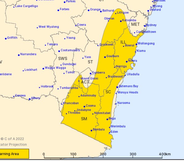
Strong west to southwesterly winds with damaging wind gusts of around 90 km/h over the South Coast district and elevated ground.
Locally damaging winds averaging 60 to 70 km/h with peak gusts of around 100 km/h are possible about the coastal parts of the Illawarra during the morning.
Damaging winds averaging 80 to 90 km/h are possible for Alpine areas above 1900 m.
Forecast snowfall coinciding with damaging winds and risk of blizzards for parts of the Snowy Mountains district above 1400 m easing during the early morning.
The NSW National Parks and Wildlife Service recommends that back country travel be postponed until conditions improve.
Winds are expected to peak in strength during the morning, before easing to below severe thresholds throughout by late afternoon.
Locations which may be affected include Wollongong, Nowra, Bowral, Eden, Bega, Katoomba, Goulburn, Cooma, Thredbo Top Station, and Bombala.
The State Emergency Service advises that people should:
* Move vehicles under cover or away from trees.
* Secure or put away loose items around your house, yard and balcony.
* Keep at least 8 metres away from fallen power lines or objects that may be energised, such as fences.
* Trees that have been damaged by fire are likely to be more unstable and more likely to fall.
* Report fallen power lines to either Ausgrid (131 388), Endeavour Energy (131 003), Essential Energy (132 080) or Evoenergy (131 093) as shown on your power bill.
* Stay vigilant and monitor conditions. Note that the landscape may have changed following bushfires.
* For emergency help in floods and storms, ring your local SES Unit on 132 500.